

About Me
Hello~! I am Hongyu Xiao, a Research Scientist at the Oklahoma Geological Survey (OGS), and a Seismologist and Computational Geophysicist holding a Ph.D. in Seismology and Tectonics from the University of Illinois at Urbana-Champaign.
My research specializes in midcontinent crustal morphology and induced seismicity, linking deep Earth structures to seismic hazards. I leverage Artificial Intelligence (AI) and Machine Learning (ML) to advance seismic detection, event classification, and subsurface characterization.
As a Research Scientist at the OGS, I investigate carbon storage safety and subsurface monitoring for the energy transition. I integrate AI/ML driven methods with traditional geophysics to improve CCS hazard assessment.
I enjoy gardening, hiking, and food exploration—finding inspiration both below and above ground. I welcome collaborations at the intersection of seismology, computational geophysics, and sustainable subsurface solutions.
Contact & Information
100 E Boyd St, Norman, OK 73019, USA
Latest Updates
-
New Paper Published in JGR: Machine Learning and Computation
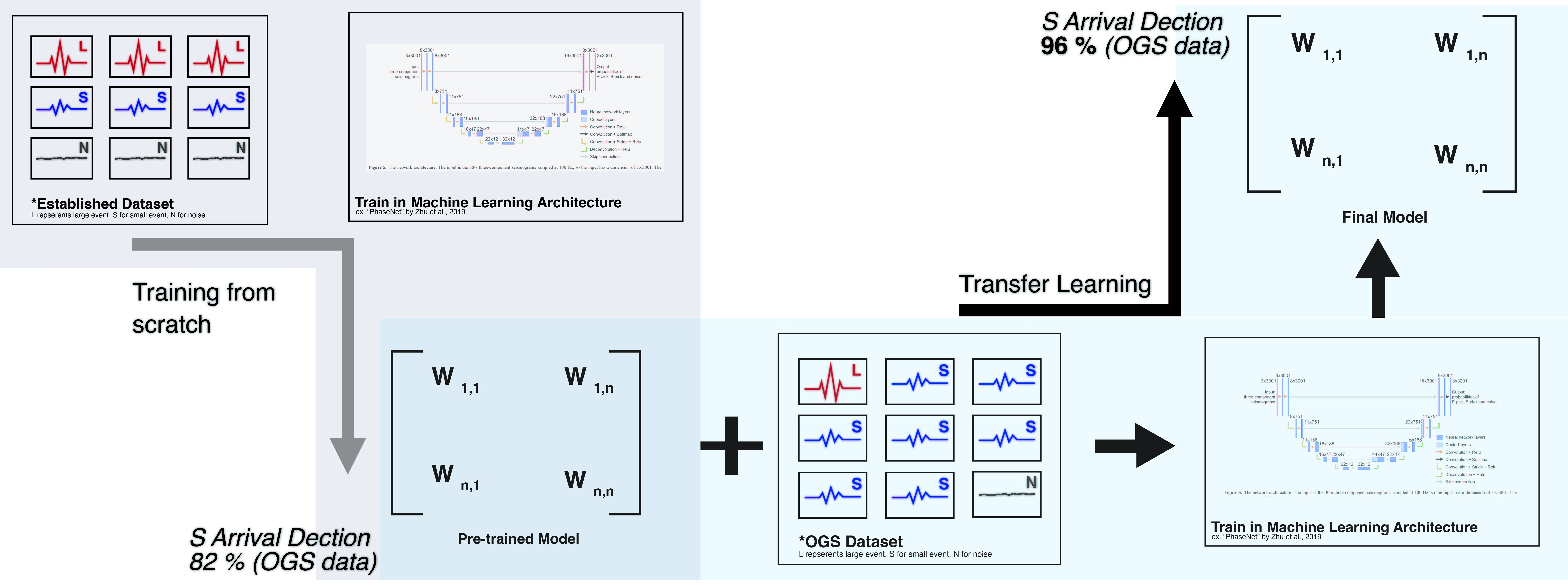
On , my peer-reviewed paper titled "Transfer Learning and Benchmarking for Induced Seismic Event Detection: Insights From Oklahoma" was published in the Journal of Geophysical Research: Machine Learning and Computation. This study addresses the challenge of detecting small, induced earthquakes that are often obscured by environmental noise. By fine-tuning machine learning models with a localized Oklahoma dataset (OKLAD), we significantly improved detection capabilities—identifying over 4,400 previously uncataloged events in 2022. This demonstrates the power of transfer learning for deploying machine learning models across new regions.
-
Promoted to Research Scientist (Geophysicist) | Oklahoma Geological Survey
In , I was promoted to a permanent, long-term Research Scientist | Geophysicist position at the Oklahoma Geological Survey, University of Oklahoma and Mewbourne College of Earth and Energy. In this role, I will conduct research in earth and energy geosciences and applied geophysics, collaborating with OGS and Mewbourne College staff, faculty, students, and external partners across industry, state regulatory agencies, and the general public. I aim to contribute and help the Oklahoma statewide seismic network, integrating noval and emerging technologies such as Distributed Acoustic Sensing (DAS) or Edge Computing, while pursuing external research funding and publication strategies to advance induced seismicity monitoring, carbon storage safety (CCS/CCUS), and AI/ML driven subsurface characterization across the U.S. southern midcontinent.
-
TinyML & Transfer Learning for Induced Seismicity Detection | SSA 2026 Invited Talk
On , I gave an invited talk at the Seismological Society of America (SSA) 2026 Annual Meeting in Pasadena, California. My presentation, "Localized Transfer Learning for Detection of Induced Seismicity Across Diverse Monitoring Systems", showcased innovative applications of transfer learning and edge AI for induced seismicity detection across varied seismic monitoring networks. This work addressed the challenges of ML model generalization and deployment scalability in seismic monitoring systems, with a focus on enabling edge computing-compatible workflows for real-time, on-device seismic inference in resource-constrained field environments.
-
ML-Aided Seismic Monitoring for Carbon Storage | DOE Short Course
On , I presented my work at a DOE-sponsored short course, “Framing the Future of Carbon Capture and Storage in Oklahoma”, for industry, regulatory, and research stakeholders. The presentation introduced a next-generation, machine-learning–aided seismic monitoring framework tailored for potential carbon storage applications, emphasizing scalable event detection, robust performance under sparse and noisy conditions, and operational relevance for CCS risk management. This work demonstrates how advanced ML-driven workflows can enhance monitoring confidence, regulatory transparency, and decision-making for carbon storage and induced seismicity mitigation.
-
DISC Seed Funding Award for AI-Based Induced Seismicity Research
On , the University of Oklahoma Data Institute for Societal Challenges (DISC) awarded seed funding to support my project, "Edge-Enabled Deep Learning for Induced Seismicity Detection in Oklahoma". This DISC Seed Funding Program supports data-enabled and data science research aimed at addressing complex societal challenges and advancing projects toward external research funding.
-
AI-Enhanced Nodal Array Detection of Induced Seismicity | AGU 2025
On , I presented this work at the AGU Fall Meeting 2025, introducing an AI-enhanced framework that integrates dense nodal seismic arrays with fine-tuned machine learning models for induced and microseismic event detection. The approach improves detection sensitivity and monitoring reliability in the U.S. southern midcontinent, with direct relevance to carbon storage monitoring, induced seismicity hazard assessment, and subsurface risk management.
-
Machine Learning for Microseismicity Monitoring | ES-SSA 2025
On , I presented at the Eastern Section Seismological Society of America Annual Meeting, St. Louis, Missouri. My talk, "Machine Learning for Effective Microseismicity Monitoring", demonstrated benchmarks, adaptable models, and datasets for microseismic monitoring and carbon sequestration safety in Oklahoma. The presentation was well received and sparked discussions on AI-driven seismic monitoring and geophysics applications.
-
Crustal Shear Velocity Anomalies in the Midcontinent | ES-SSA 2025
On , I presented at the Eastern Section Seismological Society of America Annual Meeting, St. Louis, Missouri. My talk, "Unveiling Shear Velocity Anomalies in the Central Midcontinent of the United States through High-Resolution Joint Inversion", showcased high-resolution seismic imaging, joint inversion of surface waves and receiver functions, and new insights into crustal and uppermost mantle structure beneath the North American craton. The results highlight crustal features and have implications for craton evolution and intraplate seismicity.
- Check more previous news @ archived_news.html
Research

Illinois Basin / Michigan Basin / Midcontinent / The United States
Receiver function analysis
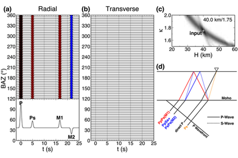
Receiver functions (RF) are time series computed from three-component seismic timeseries, and they indicate the Earth structure near the station (receiver) [Langston et al 1978].
The H-κ-c method is a generalized receiver function method with harmony corrections on P to S converted phases and the corresponding crustal multiples, essentially improving the estimates of crustal thickness (H) and the ratio of P to S velocity (Vp/Vs ratio, κ) [Li et al JGR 2018].
Illinois Basin / Central Midcontinent / The United States
Ambient Noise tomography
Ambient noise tomography (ANT for short) is a seismic imaging method using coherent signals extracted from seismic ambient noise records to construct tomography of the earth interior. By calculating cross-correlation of noise signals, we could recover the coherent surface wave signals hidden in the noise records which is called Empirical Green’s Function.
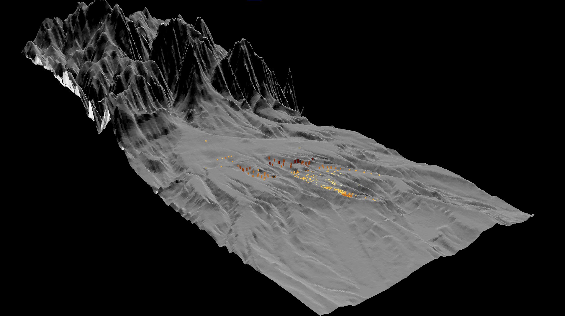
Illinois Basin / Central Midcontinent / The United States
Joint inversion tomography
Ambient nnoise imaging is sensitive to velocity structures however lack of the power to detect sharp discontinuity/large impedance contrast. Receiver function is sensitive to large impedance contrast however unable to track velocity structure.
The joint inversion could overcome the potential tradeoffs during inversion processes. The tomography model provides very detailed shear velocity structures in central midcontinent.
Oklahoma / Induced Seismicity / Machine Learning
Machine Learning in Induced Seismology Research
This research leverages advanced machine learning techniques to enhance the monitoring and analysis of induced seismicity. Using transfer learning, we refine seismic detection models to identify low-magnitude events with minimal false negatives, a critical need for induced seismicity monitoring in Oklahoma. This approach enables rapid deployments while maintaining high performance, providing a practical tool for understanding anthropogenic earthquake processes.
Education
Working with Dr.Xiaodong Song at University of Illinois Urbana-Champaign (UIUC). Dr.Xiaodong Song is currently at Peking University as Chair Professor of School of earth and space sciences now
My research projects were about the lithosphere morphology and the seismic velocity structure of the midcontinent in the United States
Worked with Dr.Douglas R. MacAyeal at University of Chicago in Hyde Park.
My research project was a multiple-layer neural network (a.k.a machine learning) model for Early Earthquake Warning Systems based on historical seismicity records.
I managed large datasets of seismic records using supervised training and did many data cleaning, manipulation, preprocessing, and feature design.
Worked with Dr.Ji Hancheng at China University of Petroleum,Beijing.
My undergraudate thesis was "Genetic analysis of chert in Wumishan formation." I conducted Total Organic Carbon (TOC) Analysis for the hydrocarbon source rock samples from Wumishan formation.
G.P.A. 3.88/4, Top Graduates from competitive Honor Program
Professional Skills
Machine Learning & AI
Programming & Scientific Computing
Geophysics & Data Tools
Web & Visualization
Selected Publications
-
JGR Transfer Learning and Benchmarking for Induced Seismic Event Detection: Insights From Oklahoma
Published in Journal of Geophysical Research: Machine Learning and Computation (2026). This study addresses the challenge of detecting small, induced earthquakes by fine-tuning machine learning models with a localized Oklahoma Labeled AI Dataset (OKLAD). It demonstrates the power of transfer learning for deploying models across new regions, identifying over 4,400 previously uncataloged events.
DOI: 10.1029/2025JH001194Human activities such as wastewater injection and hydraulic fracking can trigger earthquakes. In the southern midcontinent of the U.S., such induced earthquakes have become more prominent in the last decade. However, the ground vibration signals of these from small and induced earthquakes are often buried in environmental noise, making them difficult to detect using traditional methods or by through visual inspection from seismic analysts. Recently, machine learning models have shown great promise in improving the ability to detect small earthquakes. In this study, we fine-tuned machine learning models using an Oklahoma-focused data set (OKLAD) and compared their performance to existing models. Our results show that even with a relatively small amount of localized data, the models' ability to detect small earthquakes can be substantially improved. Applying the best model to 2022 data, we recovered nearly all previously cataloged events while identifying more than 4,400 additional events. These results show that OKLAD can serve as a benchmark for earthquake detection and that transfer learning is an effective strategy for applying machine learning across regions. We are releasing both our trained models and the data set to the public to support future research on induced earthquakes.
-
GRL Crustal Thickness Variations in the Central Midcontinent, USA, and Their Tectonic Implications
Published in Geophysical Research Letters (2022). This paper provides the first high-resolution Moho depth map for the Central Midcontinent using a revised H-κ-c receiver-function method, revealing new insights into crustal architecture and intraplate tectonics.
DOI: 10.1029/2022GL099257Studies of the central midcontinent region of the USA, a portion of North America's relatively stable craton, reveal that both the Moho (the crust/mantle boundary) and the surface of the Great Unconformity (the boundary between crystalline basement and overlying Phanerozoic sedimentary cover) have kilometers of relief, even though land-surface relief in the region is, at most, 0.5 km. To clarify the nature of variations in Moho depth, so as to make it possible to correlate these variations with other geologic features of the shallow continental crust, we applied a new, more robust, method in estimating Moho depth to data from all available EarthScope seismic stations in the region. This effort yielded a new, high-resolution map of Moho depth. Significantly, we found large undulations (ups and downs) of the Moho both at the regional scale and at the local scale. Some of these undulations correlate with the boundaries of regional basins and domes, as defined by the depth to the Great Unconformity, and others correlate with known faults. The development of thickness variations may reflect geologic events, such as addition of new rock to the base of the crust, or removal of lower crust, which happened after the crust first formed.
-
EPSL Moho Depth Variations Under the Northeastern Midcontinent (H-κ-c Analysis)
Published in Earth and Planetary Science Letters (2025). This work presents a new crustal thickness model for the northeastern Midcontinent, applying enhanced H-κ-c receiver-function method to reveal lithospheric variations that illuminate regional tectonic evolution.
DOI: 10.1016/j.epsl.2025.119289Our results emphasize that crustal thickness varies by almost 13 km in a region of North America where land-surface varies by less than 0.5 km and where relief of the Great Unconformity varies by a maximum of 7.5 km. In contrast to contemporary orogenic belts, crustal thickness does not correlate directly with either land-surface elevation or with sedimentary cover thickness (i.e., depth to the Great Unconformity). For example, the thickest crust of the study area occurs in the southwestern Illinois Basin, where land surface elevation is about 150 m, and the thinnest crust occurs in north central Indiana, where land-surface elevation is 250 m. There is a rough correspondence between crustal thickness and epeirogenic structures. In general, thinner crust underlies domes and arches, whereas thicker crust underlies basins, but there are exceptions. For example, while crust is relatively thin beneath the Kankakee and Cincinnati Arches, it is relatively thick beneath the Findlay Arch and the Wisconsin Arch, crust beneath the Michigan basin, overall, is thinner than that of the Illinois or Appalachian basins, and crust beneath the Canadian Shield is thinner than that beneath the cratonic platform. Notably, the Moho beneath the Canadian Shield and beneath the cratonic platform west of the Grenville front, displays roughly periodic long-wavelength north-south trending undulations. These undulations do not coincide with Precambrian tectonic fabrics or crustal boundaries, hinting that they developed after crustal assembly and could instead reflect variable degrees of thinning, underplating, or crustal delamination during failed Proterozoic rifting, or perhaps of crustal buckling associated with the Grenville collision.
Professional Service
-
NSF National Science Foundation (NSF) — Proposal Review Panelist
Served as an NSF proposal review panelist (panel name confidential), 2024.
-
UIUC Department of Geology Climate Working Group
Member, Climate Working Group, Department of Geology, University of Illinois Urbana-Champaign.
-
UIUC Vice President, Geology Graduate Student Council
Served as Vice President of the Geology Graduate Student Council at the University of Illinois Urbana-Champaign.
Teaching
Introduces non-science majors to physical aspects (earthquakes, volcanoes, floods, tsunamis, mountains, plate tectonics) and historical aspects (formation of earth and life, dinosaurs, ice age, evolution of climate) in earth science. Presents information on earth resources, natural hazards, and development of natural landscapes. Focuses on humanistic issues; provides context for understanding environmental change.
Develops geologic background, concepts, and principles through study of selected national parks and monuments. Examines the geologic framework and history, modern geologic processes, and factors influencing the present day landscape for each park area.
Introduction to: crystallography; crystal optics; structure, composition, properties, stability and geological occurrences of minerals; and mineral identification.
Introduces Earth phenomena and processes. Includes minerals and rocks, continental drift, plate tectonics, rock deformation, igneous and sedimentary processes, geologic time, landscape evolution, internal structure and composition of the earth, groundwater, seismology and earthquakes, and formation of natural resources. Emphasizes the chemical and physical aspects of the Earth, and the basis for geological inference.
Integrated introduction to oceanography and marine geology and geophysics. Topics include ocean-basin formation and evolution (in the context of plate tectonics), ocean ecology, the hydrologic cycle, water chemistry, currents and waves, the interaction of oceans with climate, coastal hazards, resources, pollution, and the Law of the Sea. Course is oriented toward students not majoring in science.
Introduction to principles of rock deformation, stress, and strain; description and interpretation of geologic structures; study of methods for structural analysis; outline of geotectonic processes.
Seismic Research Visualizations
AI-Powered Seismic Event Detection
Advanced machine learning application demonstrating real-time seismic event detection and analysis capabilities.
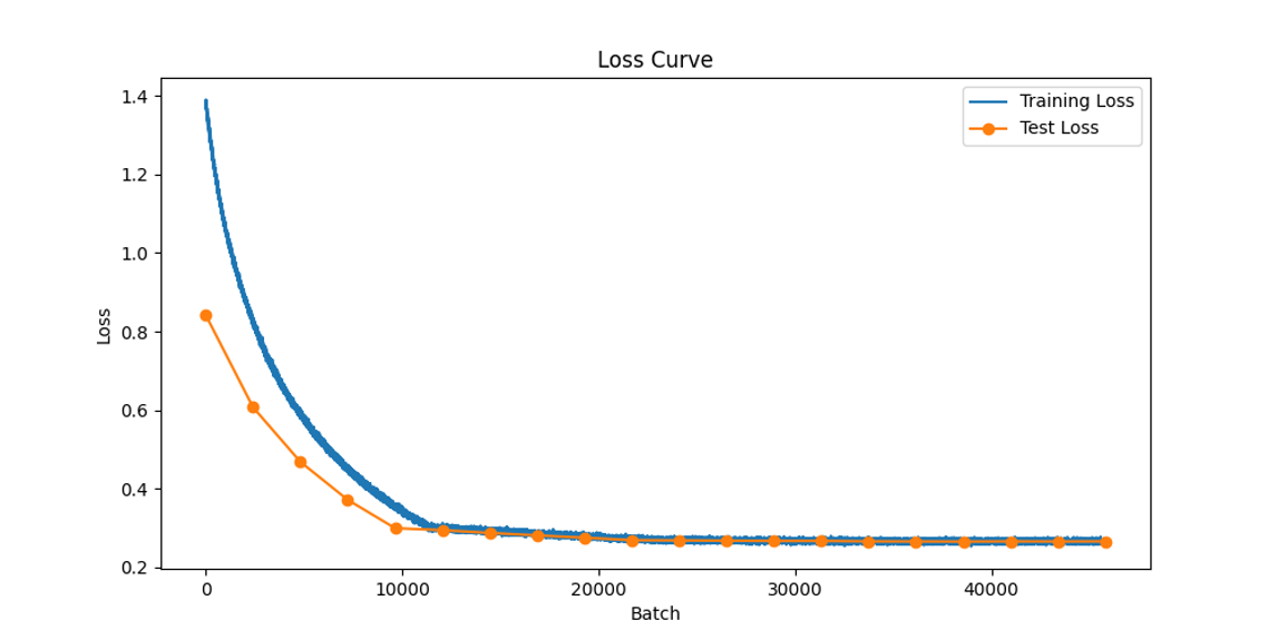
Neural Network Training Performance
Comprehensive visualization of model training progression showing loss convergence and optimization metrics.
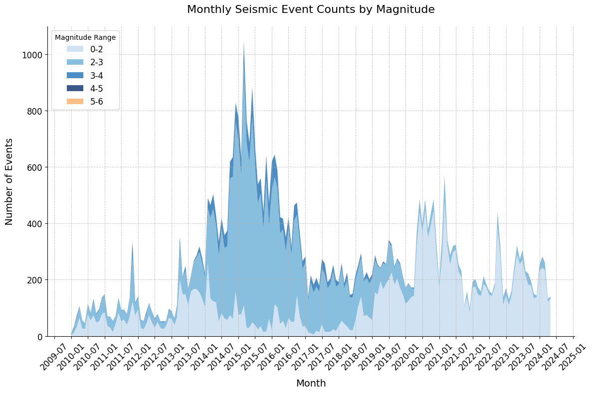
Oklahoma Seismic Activity Timeline
Comprehensive temporal analysis showing seismic event patterns and frequency distribution across Oklahoma.
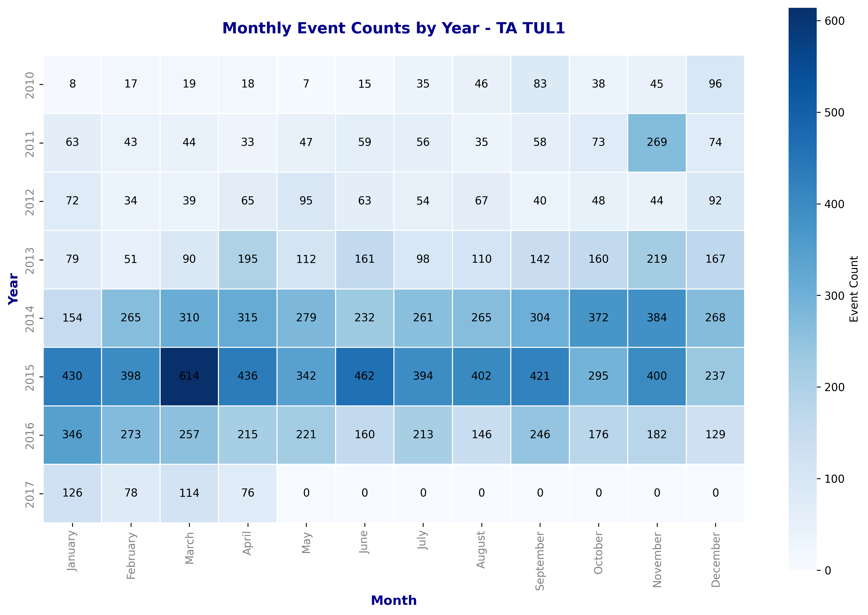
Seismic Station Data Availability Analysis
Detailed heatmap visualization of seismic monitoring station data availability patterns.
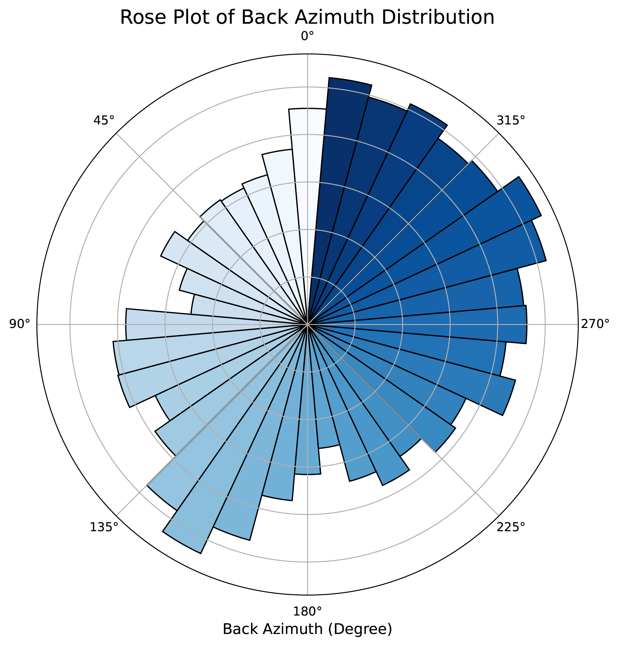
Seismic Event Directional Analysis
Detailed rose plot analysis revealing directional patterns of seismic events.
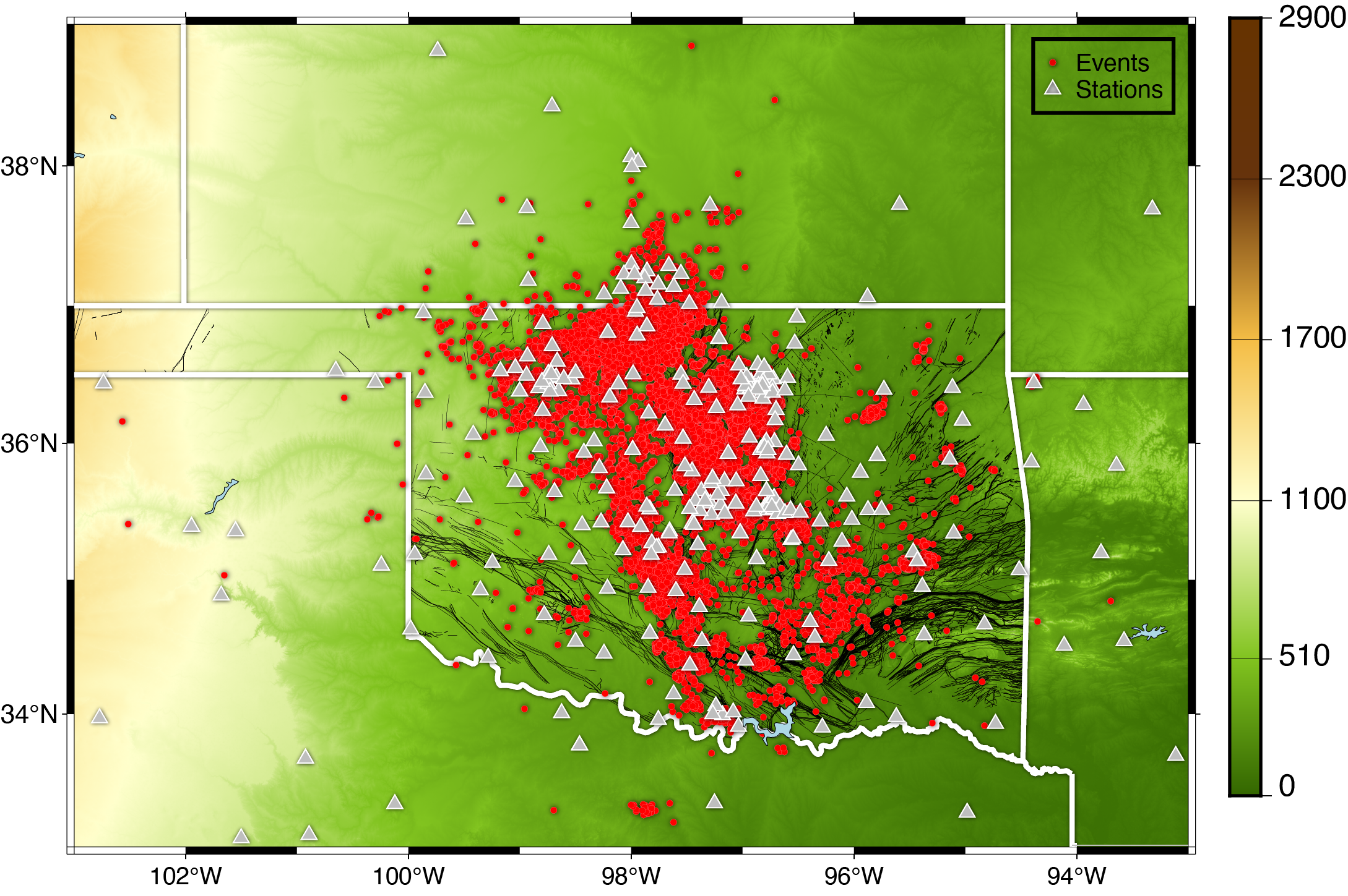
Oklahoma Seismic Network Coverage
Comprehensive spatial analysis showing the distribution of seismic monitoring stations and recorded events.
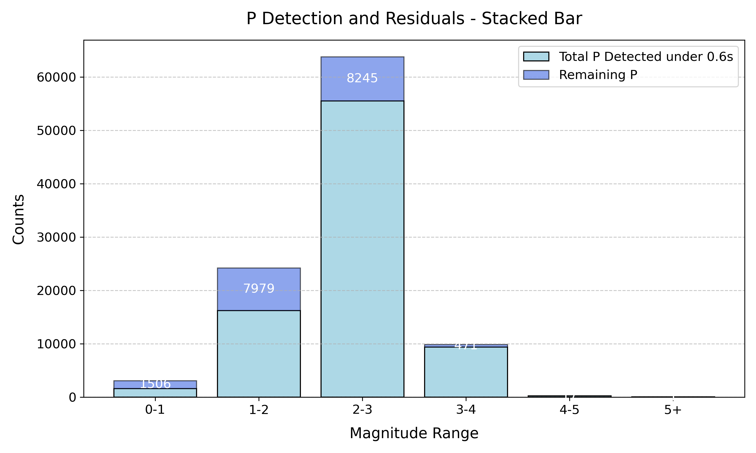
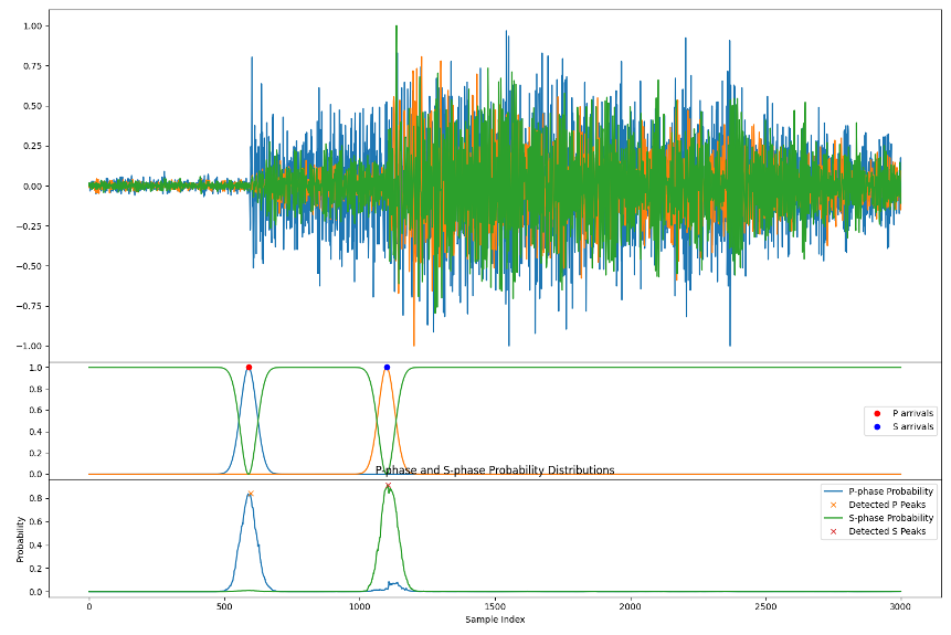
P-Phase Detection Performance Analysis
Detailed breakdown of P-phase prediction accuracy metrics using stacked bar visualization techniques.
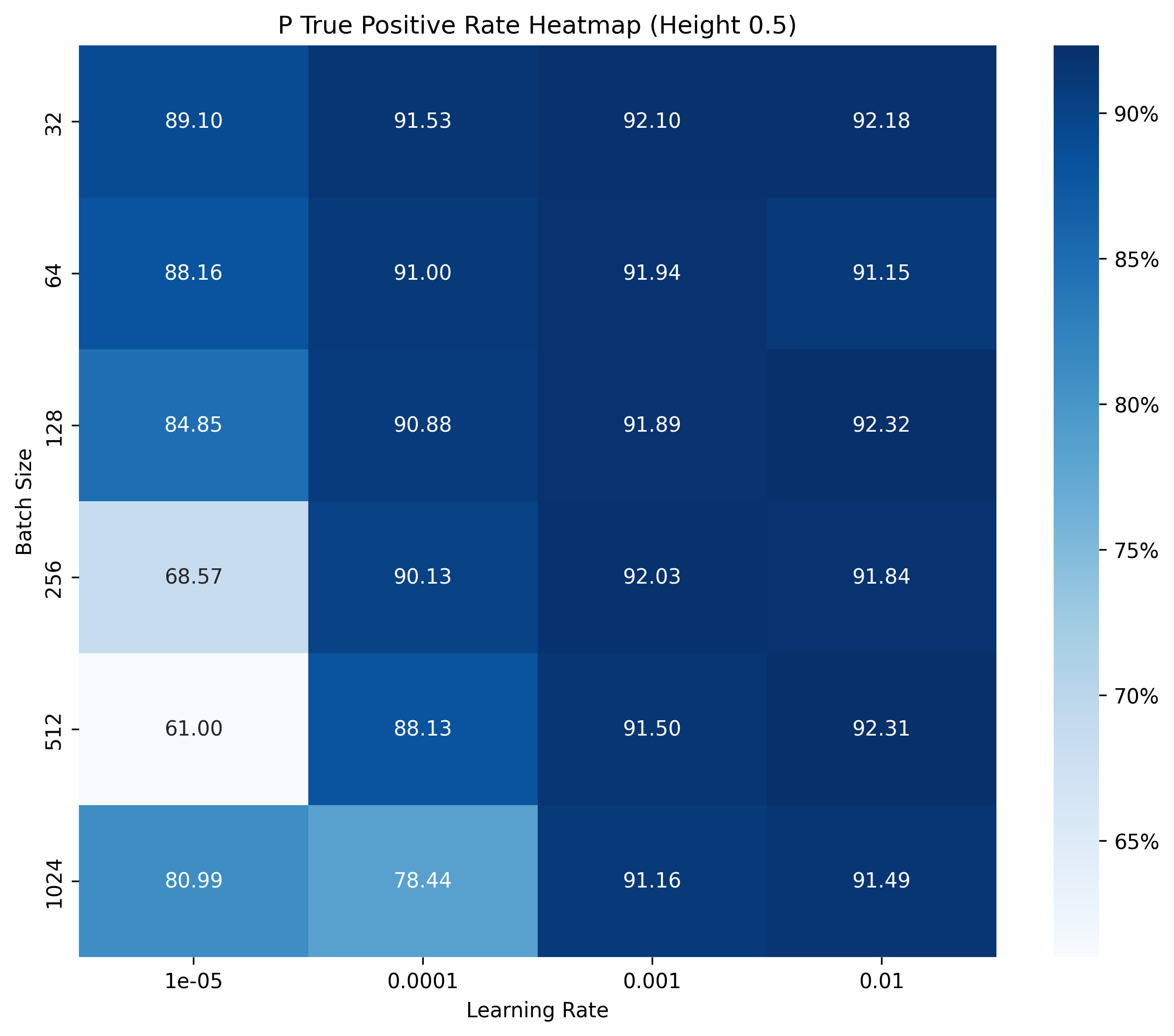
Detection Rate Parameter Optimization
Comprehensive heatmap analysis of detection rate parameters showing optimization patterns.

Detection Threshold Analysis
Statistical correlation analysis between threshold height parameters and P-phase detection accuracy rates.
A bit more about me ...
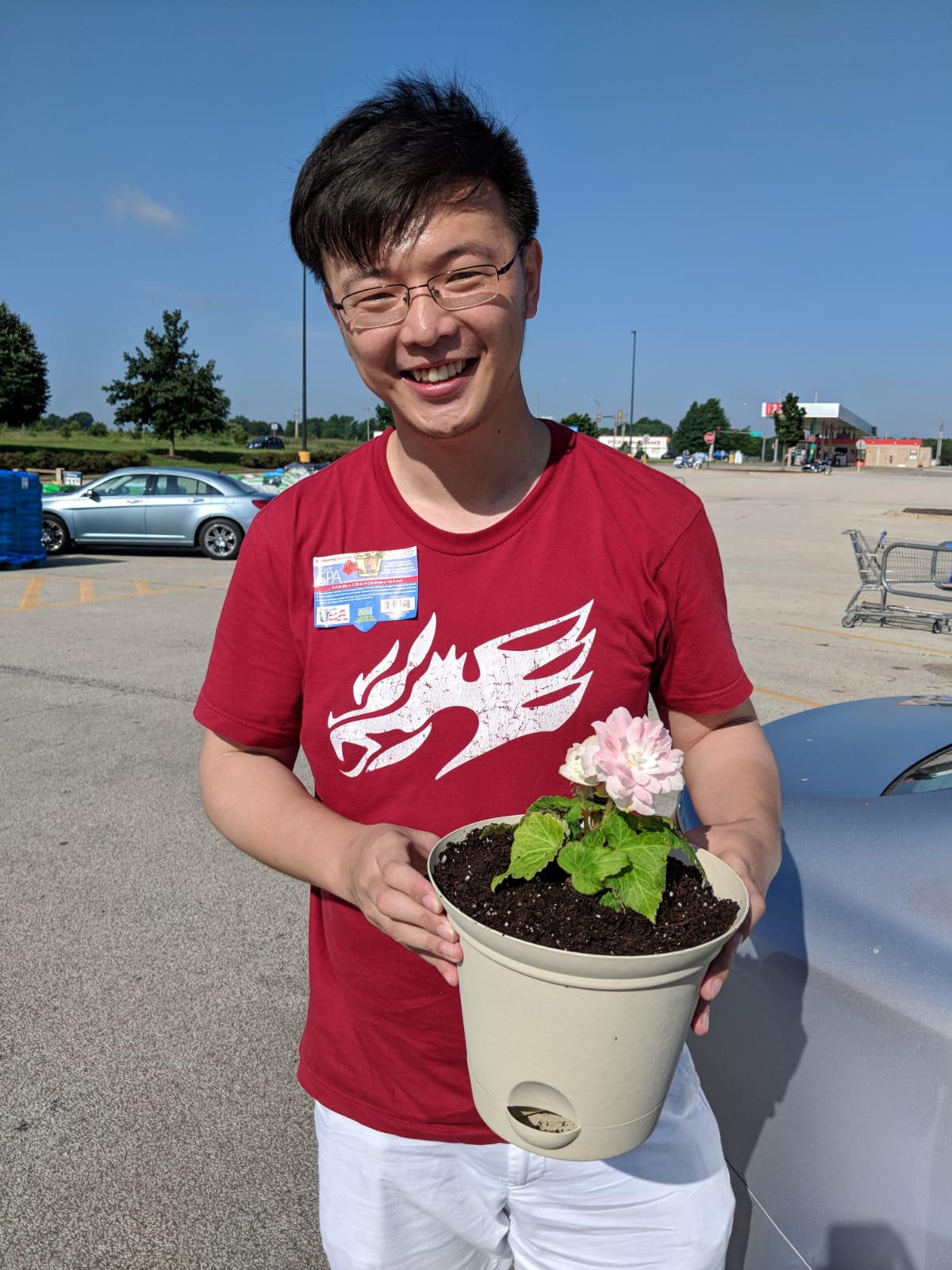
Plants / Flower / Begonia
Growing Begonia as a hobby
Growing flowers is my newly developed skills over the Pandemic. It is super fun to watch them grow
I have varies flower plants like Begonia,Roses, Lilies etc Most of them actually survived the winter under my care!
Now my plan for flower planting is to have flowers at all seasons!
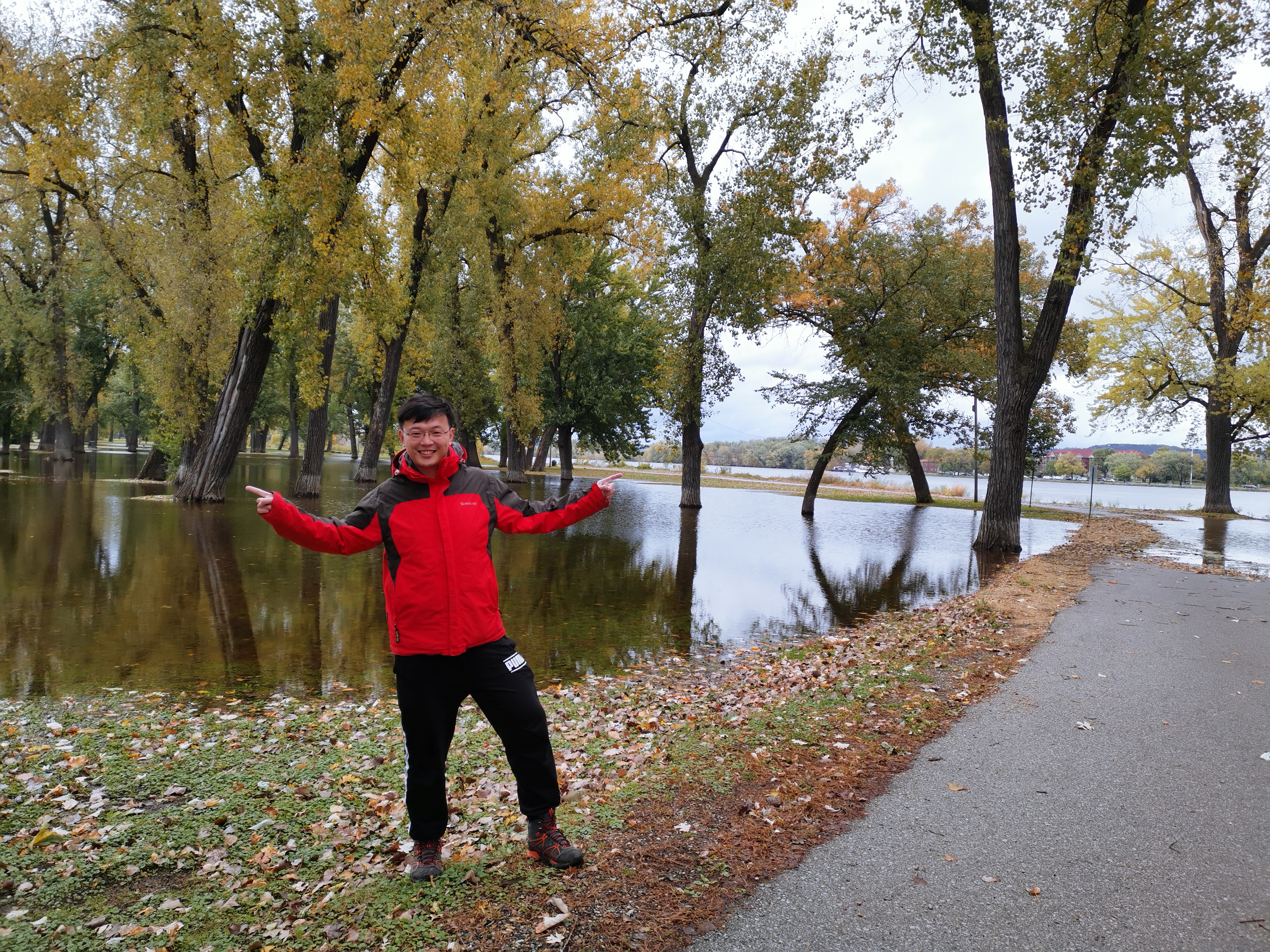
Hiking / Mississippi River / Fall
Hiking in the fall showing the Mississippi River
Hiking is one of my preferred way of vacation. I love to see the fall foliage in Michigan state. It is such an amazing beauty
Sometimes, the unpredictable weather could add more fun to it.
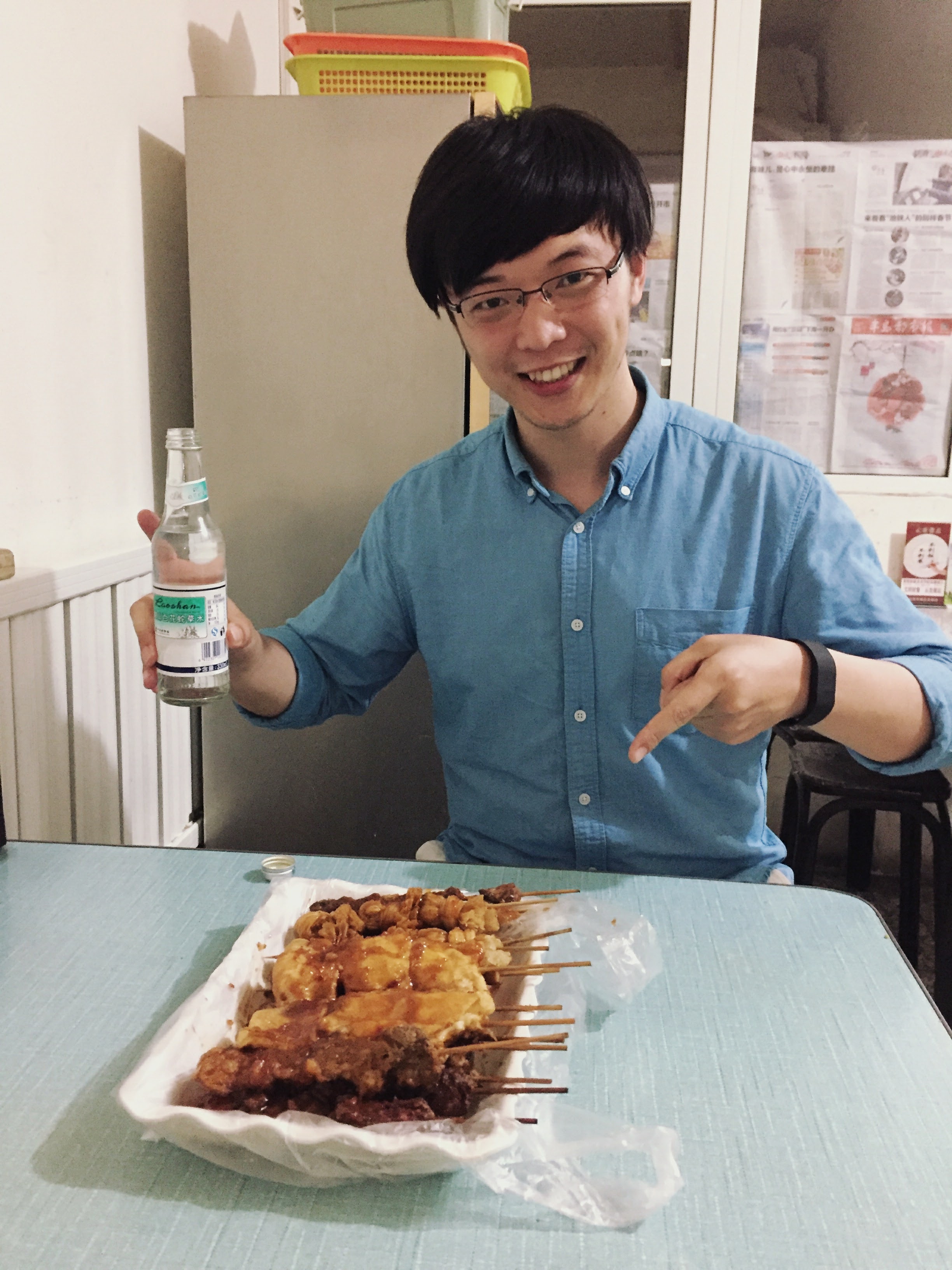
Food / Streetfood / Qingdao
Always available for food tryout !
Holding the belief that food is the simplest happiness within reach. I am always happy trying new food
Spicy food? Street food? Smelly but local food? Bring them on.
However, I am only loyal to Qingdao food taste and establish my rating based on it. :)
Visitor Counter
Contact Me
Address
Sarkeys Energy Center, Norman, Oklahoma, USA
Phone
+1 (872) 203-0968
hongyu.xiao-1@ou.edu